
Canigou Mountain: A complete guide to exploring the symbol of the Catalans
Roussillon · Sea & Mountains
Mount Canigou: A Complete Guide to Exploring the Symbol of Catalonia
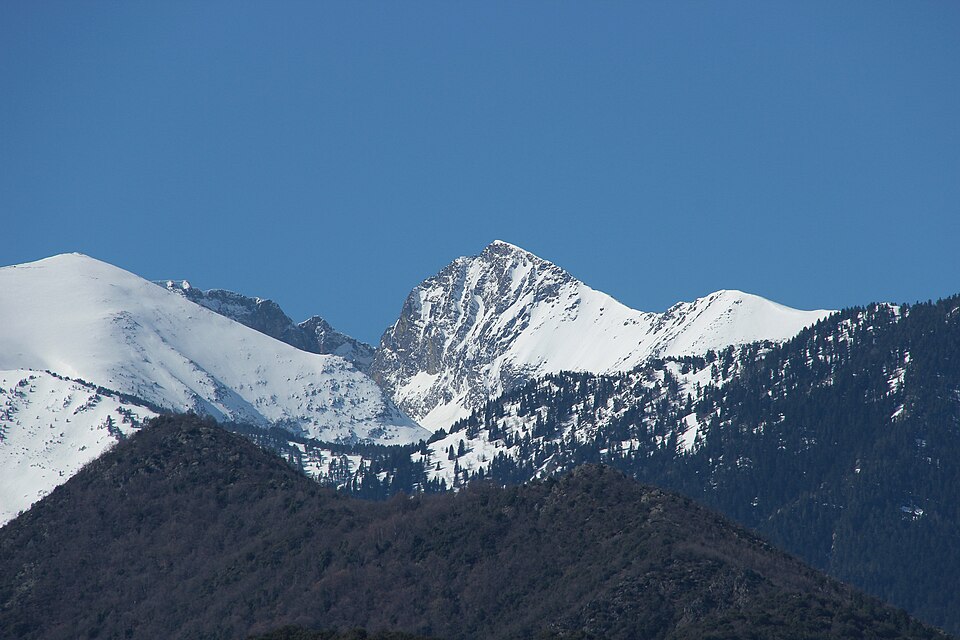
Visible from anywhere in the Roussillon plain, Mount Canigou (2,784 m) is both a major natural site, a strong Catalan cultural symbol, and a perfect playground for hikers. Here’s how to explore it from our We Are Living homes.
Hiking & Panoramas
Catalan Villages
Between Sea & Mountains
History & Identity of Mount Canigou
More than just a peak, Canigou has been the sacred mountain of the Catalans for centuries, appearing in poems, legends, and local traditions.Key Historical Facts
- A revered mountain since the Middle Ages, visible throughout the Roussillon plain.
- Long believed to be “the highest peak in the Pyrenees” before modern measurements.
- A historical passageway for shepherds, monks, hikers, and smugglers.
- Today part of a protected Grand Site de France.
The Canigou Fire
- Every 23 June, a fire is lit at the summit for the Sant Joan Festival.
- The flame is then carried down to Catalan villages to light thousands of bonfires.
- A powerful symbol of Catalan unity and identity.
Key Info
The Canigou at a Glance
- Altitude: 2,784 m
- Range: Eastern Pyrenees
- Main access: Conflent Valley (Prades, Villefranche-de-Conflent)
- Views: Mediterranean Sea, Roussillon plain, Pyrenean peaks
We Are Living tip: on a clear day, you can see Canigou from the terrace of our homes in the Aspres.
Where Is Mount Canigou Located?
The Canigou massif lies at the eastern end of the Pyrenees, in the Pyrénées-Orientales region, at the heart of French Catalonia.- About 45 minutes from Perpignan by car.
- 30 minutes from Prades, gateway to the Conflent.
- Around 1 hour from our We Are Living homes in Tresserre and Vives.
- At the edge of the Catalan Pyrenees Regional Natural Park.
Distances From Our We Are Living Homes
- Casa Tresserre → Prades: ~1 h drive
- Casa Vives → Villefranche-de-Conflent: ~50 min
- Homes → first hiking trails: from 30–40 min
Perfect for alternating beach days (Argelès, Collioure, Côte Vermeille) and mountain days around Canigou.
Where to Stay to Explore Canigou?
We Are Living
Our Homes in the Aspres Region
- Casa Tresserre – Sea & Mountains Ideal home base between vineyards, the Mediterranean coast, and the foothills of Canigou.
- Casa Vives – Countryside & Mountains Village atmosphere, open views, and quick access to the Tech Valley and Conflent.
Other Accommodation Options
- Prades: hotels & guesthouses at the foot of Canigou.
- Vernet-les-Bains: spa town, perfect after a hike.
- Villefranche-de-Conflent: UNESCO-listed fortified village.
- Mountain refuges: especially the Cortalets refuge for the ascent.
Hikes & Experiences Around Canigou
Ascent of Canigou Peak
- Duration: 6–8 h depending on starting point.
- Elevation gain: approx. +1,200 m.
- Level: experienced hikers; some steep sections.
- Classic starts: Cortalets Chalet, Vernet-les-Bains.
Easy Walks & Villages
- Cortalets Loop: panoramic views without reaching the summit.
- Saint-Martin du Canigou Monastery: a spectacular cliffside site.
- Villefranche-de-Conflent: fortified lanes, Yellow Train, ramparts.
- Vernet-les-Bains: shaded trails, waterfalls, thermal baths.
Plan a “Canigou Day” From Our Homes
From Tresserre or Vives, you can easily combine a morning hike, lunch in a Catalan village, and a peaceful evening back in the Aspres.
Useful Links to Prepare Your Visit
Always check weather conditions, possible snow cover, and access/parking availability before you go.
Also Worth Reading About the Roussillon
Complete your “Canigou & Roussillon” experience with our other articles:Map: Mount Canigou & Our We Are Living Homes
See the position of Mount Canigou in relation to our homes in the Aspres—an ideal location to combine sea, vineyards, and mountains.Click the markers to display each location’s name. Positions are indicative and adjustable.